Located on the shoreline just outside the former RAF Thorney Island (now Baker Barracks), this structure is increasingly threatened by coastal erosion. Chichester & District Archaeology Society (CDAS) has been monitoring the condition of archaeological sites identified within Chichester
Harbour since 2006, reporting findings and making recommendations for their management to the Chichester Harbour Conservancy (CHC). This project was initiated by the CHC as part of their Heritage Lottery funded project, Rhythms of the Tide.
On Thorney Island the features are pillboxes, air raid shelters and gun emplacements, dating from 1938 onwards when an airfield was established on the island. CDAS maintains a record for each site and prepares and annual programme of work to clear vegetation etc. The work programme is divided up between CDAS, CHC and the Ministry of Defence (MoD).
The southern shore of Thorney Island has seen the coastline recede by several metres in recent years. A type 23 Pillbox situated just beyond the end of the main runway is now threatened with collapse and eventual toppling into the sea. The pillbox is a very good example of this type which has an integral emplacement for a light anti-aircraft machine-gun.
We decided to make a 3D model of the pillbox, using photogrammetry before it deteriorated any further, see below.
Press the 'play' symbol, then when the model has loaded left mouse click and hold to rotate, right mouse click and hold to pan, mouse scroll wheel (or hold Ctrl + drag) to zoom. Click on any numbered annotations for more information.
The full report on intertidal fish traps at East Head by Peter Murphy has now been completed and is available for download.
Coastal survey and monitoring by CDAS has been limited recently, partly due to adverse conditions on site at Medmerry (an accumulation of sand over the structures currently exposed) and partly to Covid uncertainties. However, the first report on CDAS’s work at Medmerry has now been published in SAC (Sussex Archaeological Collections), available for download here. In addition, the fish traps at East Head have now been dated to the post-medieval period. A short report for CBASE (who funded this dating) with an image of part of one of the fish traps by Peter King is available via this link. A full report on East Head will be written soon, once plans have been prepared from surveys undertaken by Therese Kearns, formerly of CITiZAN. This will be posted here on the CDAS website and a short summary note will be submitted to SAC. Further work has been undertaken at the 19th century Coastguard Station at Medmerry. An ortho-rectified plan and an interactive 3D model prepared by Hugh Fiske can be seen below in the summary for 2020. David and Anne Bone are undertaking documentary research on this building. Once all the data on the Coastguard Station are assembled this, too, will be written up.
Future work will involve detailed survey and geoarchaeological work on the large (probably medieval) fish trap at Medmerry. This will be done in collaboration with CITiZAN and discussions are underway to determine how this will be done.
Peter Murphy
This structure was uncovered by winter storms in January 2020, it is suspected to be the southern wing of the former Coastguard Station shown on the OS map of 1875 but which had disappeared before the next survey 20 years later.
Coastguard Station, Selsey by Hugh Fiske on Sketchfab
Press the 'play' symbol, then when the model has loaded left mouse click and hold to rotate, right mouse click and hold to pan, mouse scroll wheel (or hold Ctrl + drag) to zoom. Click on any numbered annotations for more information.
An orthorectified image of this model from which a scaled plan can be traced is downloadable here. The ranging poles are 2m long.
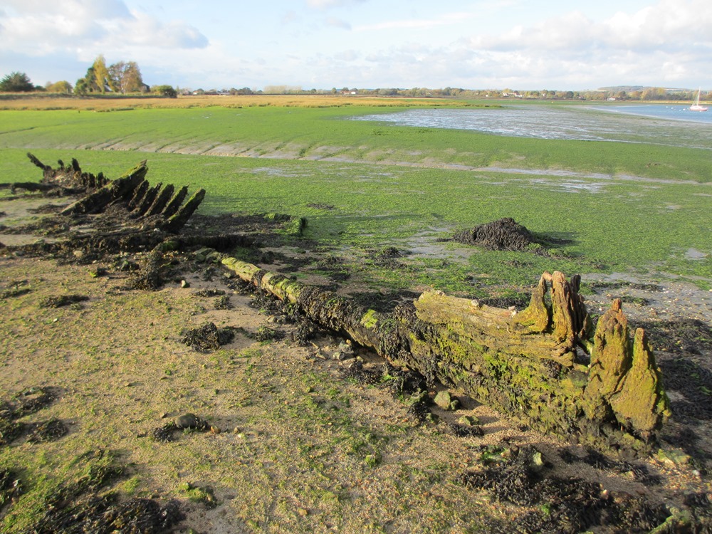
The hulk of a carvel-built flat-bottomed sailing barge of probable late 19th-20th century date lies adjacent to an ultimately failed attempt at land-claim and road construction between Chidham and Bosham at location SU 80041 03872. Completed by 1815, it now comprises an eroded embankment with a complex line of posts (perhaps with the base of a sluice, Chichester Harbour Conservancy 2007). Earlier attempts to identify and name the vessel have been unsuccessful.
The vessel is 14.7m in length, prow to stern. Part of a corroded pintle/gudgeon still attaches remnants of the rudder to the stern. Ribs survive only towards the stern. A large futtock supports what may be the mast-step. Concrete has been poured between the ribs towards the stern, now forming discrete blocks and preserving the form of the lost boards. The ribs and keel have iron reinforcements and the boards are secured with iron pins, 2cm in diameter. The surviving boards are fixed to the ribs with ship nails. Other components litter the area.
In many places hulks were emplaced to form break-waters and to form parts of sea- walls (Murphy 2014, 107). The infilling of this hulk with concrete to fix it in position may indicate a similar final end-use – though whether it is in its original position or has been displaced by storms is unclear.
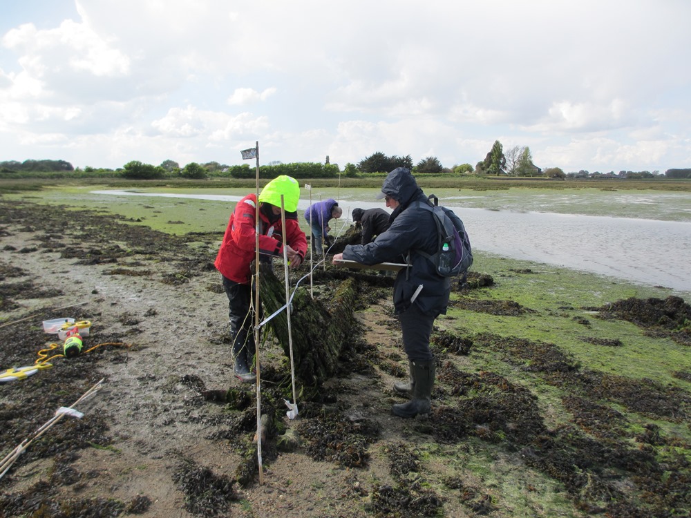
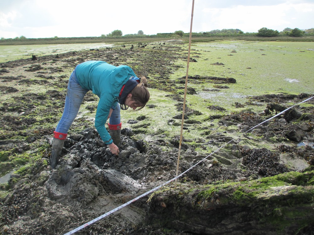
A partial plan was completed by CDAS on 26.4.17 showing the main components, see working photos and a 3D model of the site below.
Peter Murphy
Murphy, P. 2014, England’s Coastal Heritage. A review of progress since 1997. English Heritage: Swindon.
Press the 'play' symbol, then when the model has loaded left mouse click and hold to rotate, right mouse click and hold to pan, mouse scroll wheel (or hold Ctrl + drag) to zoom. Click on any numbered annotations for more information.
Peter Murphy's presentation given at CITiZAN conference in October 2016
Environment Agency Report: Medmerry Managed Realignment - Monitoring Update: Summer 2016
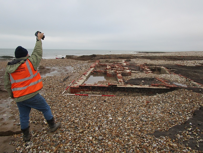
A development at Medmerry following last winter's storms (2015/6) was the exposure of substantial masonry remains of the former Thorney Farm which was lost to the sea in the early 20th century. These were surveyed and planned by CDAS members before they disappeared completely; erosion undermined the remains and nothing now remains to be seen. A chalk-lined well associated with the farm was also exposed and recorded.
The RSPB blog for Pagham and Medmerry Nature Reserves has more photos showing how rapidly the coast is eroding.
See below for 3D models of the farm remains and the well.
Thorney Farm, Medmerry by Hugh Fiske on Sketchfab
Medmerry Well by Hugh Fiske on Sketchfab
Press the 'play' symbol, then when the model has loaded left mouse click and hold to rotate, right mouse click and hold to pan, mouse scroll wheel (or hold Ctrl + drag) to zoom. Click on any numbered annotations for more information.
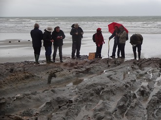
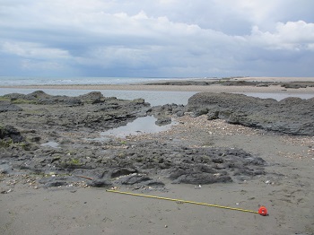
The Chichester and District Archaeology Society is monitoring and recording archaeological sites exposed by erosion on the shoreline of Chichester and Langstone Harbours and in the Selsey area. The coastline between East Wittering and Selsey has been eroded by the sea for hundreds of years. The Environment Agency has now completed the Medmerry Managed Realignment Scheme, with new defences to combat the risk of flooding, and to allow 183 hectares to revert to salt marsh and mud flats as a nature reserve - with a new breach channel cut through the shingle bank. Currently this channel changes its form week by week as it develops a more stable course.
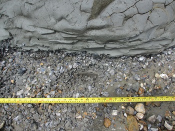
West of the breach the beach is eroding rapidly, exposing sites dating from the Bronze Age to the 20th century. Spreads of heat-shattered flint on an old land surface are most likely of Bronze Age date and were produced when hot water was produced using heated flints, perhaps for bathing. Further west, at Earnley, a skeleton was found by Mrs Cathy Dennis and lifted, unfortunately, by the police rather than archaeologists. It is dated by radiocarbon to 760-410 BC, in the Early Iron Age. The remains are of a middle- aged man who had a healed injury to his shoulder and suffered from osteoarthritis of the spine and had had a poor diet. Unfortunately this part of the beach is usually sand-covered, so we have not been able to determine the skeleton's stratigraphic context.
Close to the breach erosion, caused partly by the shifting channel, has exposed timber and wooden structures. Most of these are undated, though a fish basket has produced a radiocarbon date of 1449-1635 AD. Nearby are two timber structures comprising lines of posts with braces and wattling. Originally interpreted as fish traps, these now seem more likely to be channel revetments (see 3d model below) and samples for radiocarbon dating have been collected. It is always unwise to anticipate results but they may prove to be of similar date to the basket.
Medmerry Fish Traps by Hugh Fiske on Sketchfab
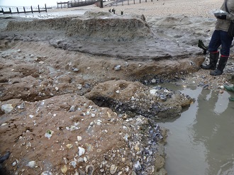
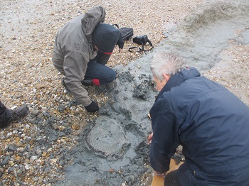
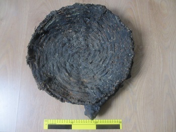
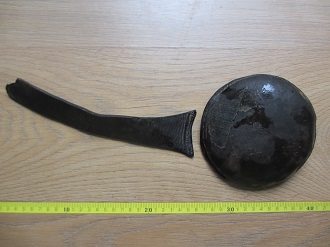
The area was used as a firing range in the Second World War, and afterwards, and it commonly produces remains of munitions, besides concrete and brick rubble. One unusual feature is the survival of beach scaffolding, which would have been draped with barbed wire. Such military defences were once almost ubiquitous around the low-lying coasts of England, but in less remote areas have later been removed for recycling. Other finds from the beach include part of a barrel (undated at present, see image below), embedded in grey clay, unstratified ship nails derived from an offshore timber wreck or wrecks and a leather slow-match pouch, of a type used in the 18th century by Royal Marines to ignite grenades (image below). Monitoring will continue as this beach erodes further back.
Peter Murphy

The storms of winter 2013-2014 exposed many new archaeological sites on the English coast due to erosion. There is nothing new about this, but the Selsey coast is eroding especially rapidly, particularly along the beach that fronts the new Managed Realignment site at Medmerry. This is a coastline that has eroded significantly in recent centuries, leading to the loss of farms and coastguard stations.
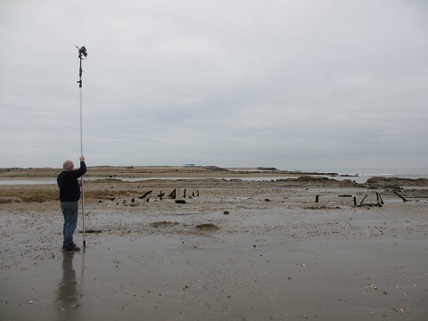
Members of CDAS became involved in survey work in early 2014, and work has continued all year. The main sites exposed are 'burnt flint mounds', which are likely to be of Bronze Age date. So far, we have recorded several such sites, using a GPS, (to record location), and levelling, to determine their elevation in terms of OD), besides augering (to see whether they are sitting in 'solid' geology or deeper intertidal sediments).
No-one is sure what the function of these sites was: but it certainly involved using heated flints to boil water, usually in pits. There have been many suggestions about function: bathing sites with saunas, cooking, food drying, malting, dyeing are all possible. The one thing we do know is that people needed hot water!
Later sediments have also produced wattle fencing, related to static fish traps, and two fish baskets. These have been lifted and sent to Archaeology South East for further recording, study and dating. We think that these are likely to be of medieval date (or later), but only radiocarbon dating will confirm this.
Peter Murphy
Medmerry Geophysical Survey, Ham Farm, 2011